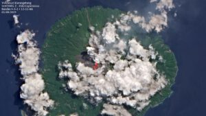
 The dome in the southern crater of the Indonesian volcano Karangetang continues to grow, and numerous rock avalanches are occurring, leaving glowing traces in nighttime images. There are also signs of a sluggish lava flow making its way down the southern flank. On long-exposure photos, the glowing traces of the rock avalanches are not always distinguishable from lava flows. A daytime image shows bluish gas emissions emanating from the flank, indicating a lava flow. A satellite photo from August 1st reveals two thermal anomalies in the infrared range, possibly originating from lava flows. The distinction between rock avalanches and lava flows is uncertain here as well.
 Marc Szeglat
Larger explosion and lava flow at Stromboli
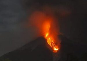 Yesterday evening at 7:06 PM, an explosive eruption occurred, which was stronger than the everyday eruptions at Stromboli. This is indicated by a report from INGV. The entire crater terrace was covered with tephra. However, according to current knowledge, there were no impacts of larger blocks or bombs on Pizzo or along the Cima, where tourists were previously allowed. In connection with the explosion, two lava overflows also occurred from the northern crater area. The lava fronts quickly reached the upper part of the Sciara del Fuoco. Similar lava overflows had already been observed in the past few days. At that time, the activity was accompanied by lava spattering. I already pointed out last week that lava flows on Stromboli usually form in phases. During such phases, there is also an increased danger of stronger explosions and paroxysms, which can even generate pyroclastic flows extending to the sea.
Stromboli erupts short lava flow
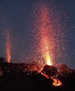 In the last few weeks, the liparic island volcano Stromboli has shown its charming side, delighting tourists with its daily eruption show, visible from the two viewpoints at 290 and 400 meters above sea level, with the higher viewpoint accessible only with a mountain guide. Yesterday, the show took a new turn as another component was added: a lava flow began to move on the outer side of the crater towards Sciara del Fuoco. The activity was accompanied by intense tephra ejections from at least 2 vents in the northern crater area. Such lava overflows are often accompanied by lava spattering and occur in phases. Occasionally, during these events, dangerous pyroclastic flows can be generated, flowing all the way to the sea.
Fagradalsfjall: Expected eruption in Iceland has begun
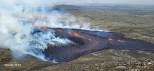 Around 4:20 PM (local time), a approximately 200-meter-long eruption fissure opened near the Fagradalsfjall volcano. The fissure is located northeast of the volcano in a place called Litli Hrútur, which has been considered as a possible eruption site in recent days. The Icelandic Meteorological Office (IMO) recommends not to go there immediately and wait for the experts’ approval. There is no full closure of the area yet.
The current eruption appears to be initially small, but it is unclear how it will develop. Previous eruptions in 2021 and 2014 started similarly modest but later intensified significantly.
The terrain behind Fagradalsfjall is flat, and there are no valleys for the lava to fill. The lava flows with a weak slope towards Fagradalsfjall, where it will encounter a volcanic elevation that acts as a natural obstacle. If the slope is balanced, the lava could flow northwards.
In the evening, two more short fissures opened in the vicinity of the first eruption fissure, slightly offset to the side. I estimate their total length to be about 350 meters. The first fissure opened precisely on a jeep track.
There are reports of evacuated hikers from the eruption area. Roadblocks are being set up, and the previously announced restricted area around the eruption site is being established.
Paroxysm at Etna volcano on 21.05.23
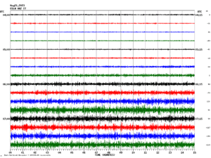 Early this morning, the tremor at Mount Etna in Sicily increased sharply. Residents of Andrano, in the southwest of the volcano, reported loud explosion sounds, clanging windows, and ashfall. As the eruption progressed, it became clear that a paroxysm from the New Southeast Crater had begun. The eruption ended shortly before 12 noon. The dense clouds gave only a brief glimpse of a lava fountain. Two days before the eruption the Tremor increased and some ash puffs were visible.
Fuego paroxysm on 05.05.23
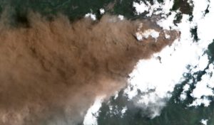 The phase of increased activity at Fuego that began yesterday escalated into a paroxysm. Volcanic ash rose to an altitude of 7600 m and drifted 200 km to the west. The ash cloud posed a danger to air traffic. Lava fountains shot several hundred metres into the air and a lava flow passed through the Ceniza Gorge, creating debris avalanches. Last, but not least, pyroclastic flows went off. They flowed through the Seca y Santa Teresa gorges to the west of the volcano. The national road RN 14 was closed and the Civil Protection CONRED ordered the evacuation of more than 1000 people from five villages near the volcano.
Shiveluch on Kamtchatka erupts
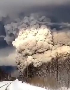 On Russia’s Kamchatka Peninsula, Shiveluch continues to be active, ejecting high rising ash clouds associated with the generation of pyroclastic flows. According to the Tokyo VAAC, volcanic ash reached an altitude of 9,500 m this morning and is spreading over a large area to the southeast of the volcano. It is very likely that further ash precipitation will occur in the village of Kljutschi, where heavy ash precipitation already occurred after the initial ignition of the volcano, covering the entire village with a brown layer of ash, causing massive problems and bringing public life to a standstill. In the meantime, it is said to be up to 20 cm thick. It must be removed from house roofs as soon as possible, because when it gets wet, the ash turns into a layer that weighs tons and can cause roofs to collapse. Since it is still winter on Kamchatka, precipitation will first fall as snow, which can be removed along with the ash. With the onset of snowmelt, however, lahars may then form on the volcano.
Magnitude 7.8 Earthquake Shakes Southwest Turkey
Date: 6th February 2023 | Time: 01:17:32 UTC | Location: 37.23 N ; 37.02 E | Depth: 10 km | Magnitude: 7.8
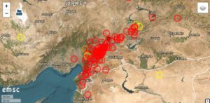 A very powerful earthquake with a moment magnitude of 7.8 struck the southwest of Turkey. The hypocenter was at a depth of 10 km. The epicenter was located 26 km east-northeast of Nurdağı. The town is home to 12,800 people. The major city of Gaziantep, with over 1 million residents, is only 37 km away from the epicenter. There have been significant damages and numerous fatalities and injuries. Images show that houses along entire streets have collapsed. The main earthquake occurred during the night, waking many people who couldn’t manage to leave their homes in time. The earthquake happened at 04:17:32 local time or 01:17:32 UTC.
According to media reports, a small tsunami occurred in the Mediterranean, even though the epicenter wasn’t located on the coast but further inland.
The earthquake occurred in the border region with Syria. The well-known city of Aleppo, which was largely destroyed during the Syrian war, is also within the affected area of the earthquake. Preliminary figures indicate that at least 280 people have lost their lives in Turkey. In Syria, over 300 deaths have been confirmed so far. Additionally, there are hundreds of injuries. The casualty numbers will continue to rise, as search and rescue operations are still in their early stages.
Update: According to the latest counts, the earthquake has caused more than 57,000 casualties in Turkey and Syria combined. Enormous property damage has also occurred.
Mauna Loa: Eruption continues
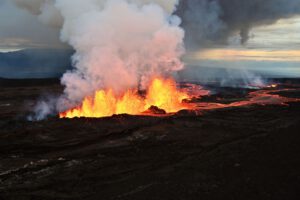 The eruption on Hawaii’s Big Island continues, and lava flows from the northeast rift of Mauna Loa volcano. During the day yesterday, the height of the lava fountains from fissure 3 was reduced to a maximum of 25 meters. On the LiveCam, it can be seen that the lava fountains are still active today. A wall of cinders is slowly forming around the active part of fissure 3. The fountains feed a lava flow with several arms. The most advanced one was moving towards the saddle road yesterday at noon at a speed of 24 meters per hour and was still 5800 meters away from it. The slope is slowly decreasing in this area, so the lava flow will continue to slow down. At the same time, the lava front is getting wider. The USGS wrote in its last update that the lava flow will take about 2 more days to reach the saddle road. I suspect it will take even longer, but if the road is disrupted by the lava, one of the main arteries between the island’s east and west will be interrupted. Motorists will then have to take a considerable detour.
New Zealand: Earthquake Mw 5,4 under Taupo
Date: 30.11.22 | Time: 10:47:59 UTC | 38.84 S ; 175.91 E | Depth: 9 km | Mw 5.4
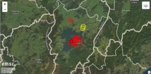 Yesterday there was an earthquake of moment magnitude 5.4 (Ml 5.6) under the Taupo caldera in New Zealand. GeoNet published more information about it today. The earthquake manifested at 10:47:59 UCT. In New Zealand, it was 11:47 p.m., which is night-sleeping time. So also the residents of the caldera were startled out of their sleep when they were shaken hard. But it didn’t stop at one shaker, as there was minor damage as items fell off shelves and some roof pieces came crashing down from a store. There were more than 180 aftershocks, 30 of which could be felt. The strongest aftershock brought it to M 4.5.
The main earthquake was the strongest since an M 5.0 earthquake in 2019, and an increase in seismicity has been observed under Lake Taupo since May 2022. Volcanologists believe the series of earthquakes is caused by activity related to magma and hydrothermal fluids inside the volcano. This activity could continue with varying speed and intensity in the coming weeks or months.