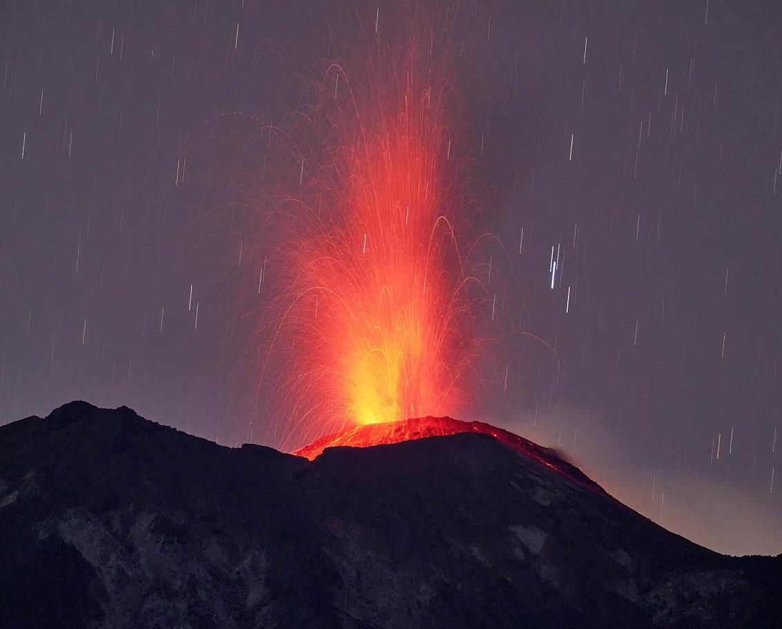
 The Lewotolok is a 1431-meter-high stratovolcano located on the Indonesian island of Lembata. It has been active for nearly three years, with only a few short periods of eruption pauses. During the summer, the eruptive activity was relatively low, with approximately 10 strombolian eruptions recorded per day. In the past week, the activity has significantly increased, and yesterday, the VSI (Volcanological Survey of Indonesia) detected 107 eruptions. These eruptions generated seismic signals with maximum amplitudes of 38 mm and durations of up to 358 seconds. The number of volcanically-induced earthquakes also increased, with 26 volcanic-tectonic tremors recorded yesterday. Additionally, there were 17 tremor phases. There were 155 signals originating from strong degassing, which was more prevalent during weeks of low eruptive activity than it is now. Up to 400 of these signals were recorded per day.
 Marc Szeglat
A new eruption began at Kilauea in Halema’uma’u Crater
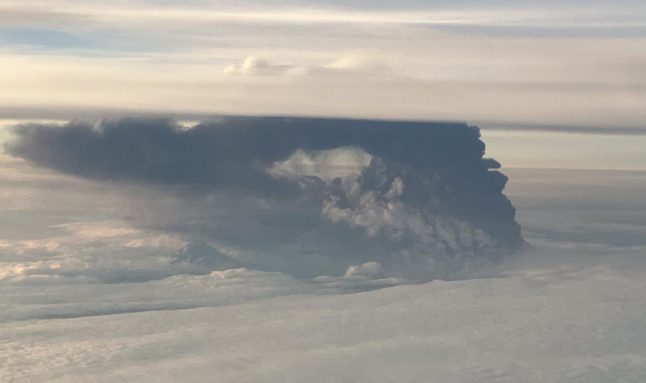
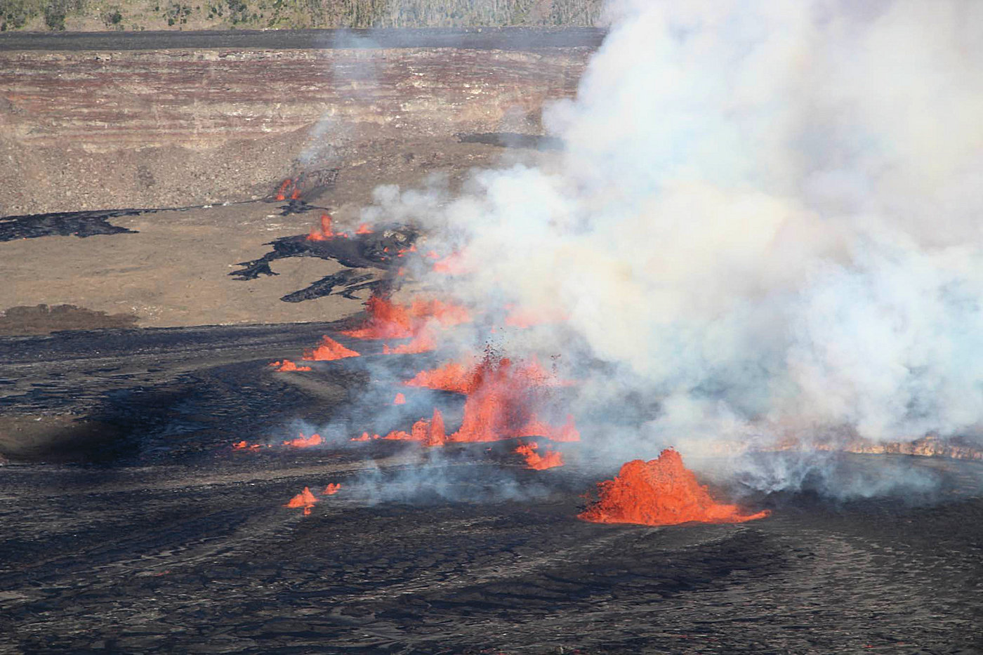 Yesterday afternoon, the Kilauea volcano erupted again. It started around 3:30 PM Hawaiian time when a 1400-meter-long eruption fissure opened in the summit caldera. It cut across the Halema’uma’u Crater and even intersected one of the blocks in the caldera that had subsided during the 2018 eruption. During the initial phase, lava fountains up to 50 meters high were produced. The lava quickly spread in the Halema’uma’u Crater, creating a large secondary lava lake that now covers most of the crater floor. An area noticeably higher than the rest of the flat crater floor remains uncovered. This area was active during the recent eruption and was built up by several layers of lava. Most of the activity along the eruption fissure has since ceased, with the majority of lava now bubbling up from a partial rift near the base of the crater wall, and some lava appears to be welling up in the opposite sector of the rift.
The volcanic eruption was not unexpected. For several weeks, there had been a significant increase in seismic activity, with daily records of between 150 and 200 minor tremors, primarily concentrated in an area south of the caldera. There were periods of significant ground uplift, which had subsided in the days leading up to the eruption. During that time, the magma that is erupting now had accumulated in a magmatic conduit.
Strong Earthquake Mw 6.9 Causes Casualties in Morocco
Date 09/08/23 | Time: 22:11:00 UTC | 31.074; -8.477 | Depth: 10 km | Mw 6.9
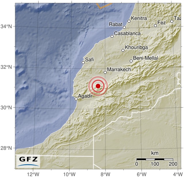 A strong earthquake with a moment magnitude of 6.9 occurred last night near Agadir and Marrakesh. The earthquake occurred at 22:11:00 UTC. The quake caused significant destruction and has resulted in 632 fatalities and 329 injuries so far. The exact depth of the hypocenter varied depending on the source: EMSC reported a depth of 10 km, GFZ Potsdam measured 27 km, and USGS determined nearly 19 km. EMSC located the epicenter 60 km west-southwest of Oukaïmedene, in a remote region of the Atlas Mountains. There were severe damages, particularly in the mountain villages near the epicenter, where numerous buildings have completely collapsed. The search for victims is still ongoing, and in many areas, there have been power outages and communication disruptions. There is speculation that landslides may have occurred, and some communities could be isolated from the outside world.
Earthquake Mb 3.8 near Solfatara triggers swarm of earthquakes
Date 09/07/23 | Time: 17:45:28 UTC | 40.83; 14.147 | Depth: 2.5 km | Mb 3.8
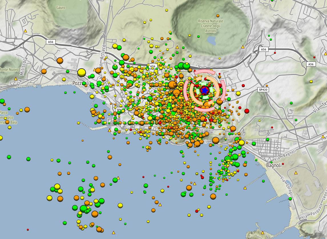 Yesterday, there was an earthquake in the Campi Flegrei Caldera with a magnitude of 3.8. The earthquake’s epicenter was at a depth of 2.5 km. The earthquake occurred near the northeastern crater rim of Solfatara, close to the thermal area of Piscarelli, and triggered an aftershock sequence with 30 subsequent earthquakes. These aftershocks mostly had low magnitudes in the microseismic range.
The main earthquake was felt in Pozzuoli and parts of Naples. EMSC received reports from people located 16 km away from the epicenter who felt the tremor. For those living closer, the earthquake was strong and frightening, but there are no reports of damage.
Explosion at Shishaldin sends ash up to 9,700 meters in height
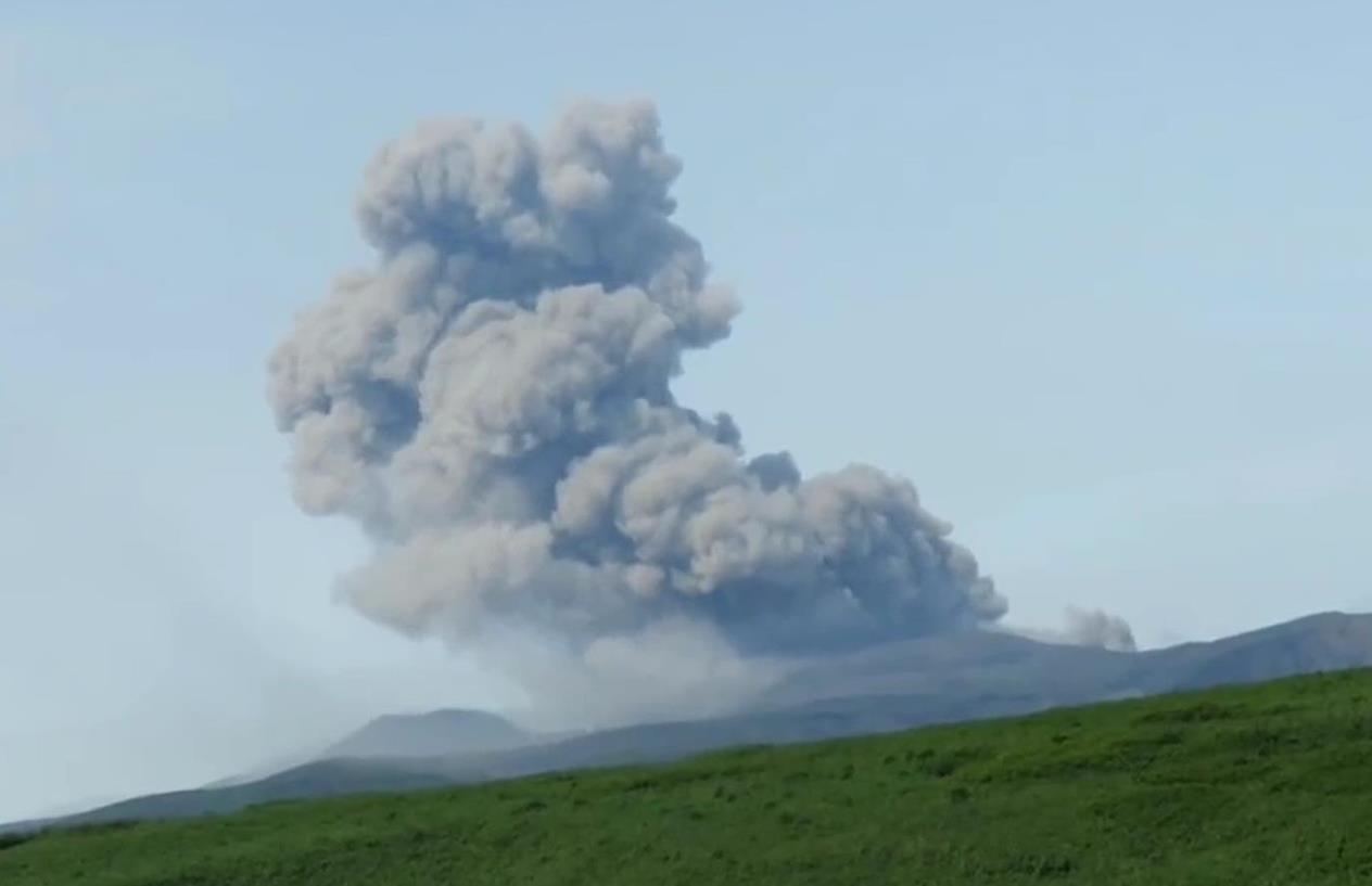
 Yesterday afternoon, around 16:30 UTC (08:30 local time), an explosive eruption of the volcano Shishaldin began. It was preceded by several hours of increasing seismic activity. The explosion produced a large ash cloud that rose to an altitude of 9,700 meters and drifted southeastward over the sea. During the eruption, a high thermal radiation of 321 MW was recorded, indicating that not only volcanic ash but also red-hot lava was erupting. The eruption caused strong tremors, clearly visible on the seismogram.
Half an hour later, seismic activity rapidly decreased, and the altitude of ash emissions observed by satellite also reduced to about 4,500 meters. By 20:00 UTC, the ash cloud had spread about 125 km in low altitude.
Shishaldin is a 2,857 m high stratovolcano on the Aleutian Island of Unimak. The Aleutians are a volcanic island arc connected to the Alaska Peninsula.
The seismicity at Mount Merapi is reaching new peak values.
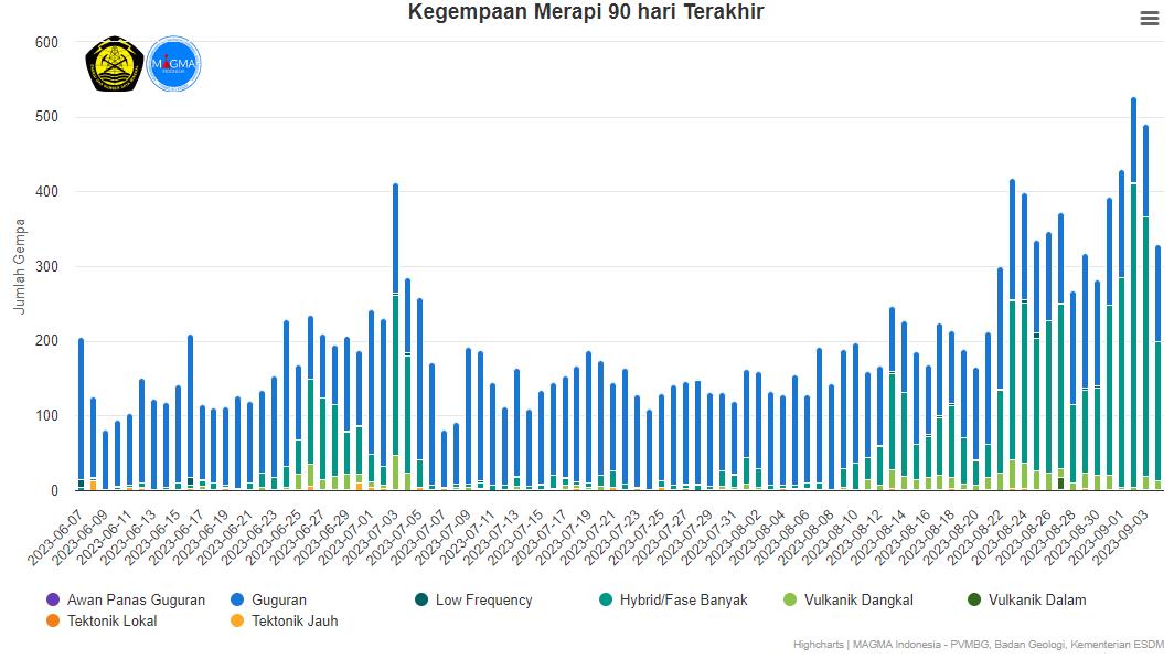 The seismic activity at Mount Merapi in Indonesia has reached new peak levels. On September 2nd, there were 407 hybrid earthquakes recorded, followed by approximately 348 of these tremors detected the following day. These are record values that are rarely reached and indicate fluid movements beneath the volcano. It is expected that the growth of the volcanic dome will continue in the coming days and could potentially intensify.
In addition to the numerous hybrid earthquakes, other volcano-tectonic tremors have also been detected. Yesterday, 129 seismic signals indicated rockfall avalanches, increasing the risk of pyroclastic flows.
In their latest weekly report, researchers from BPPTKG explain that there have been morphological changes in both domes growing inside the volcano’s crater. The most significant changes were observed in the southwestern dome. The volume of this dome was 2,858,600 cubic meters, compared to 2,764,300 cubic meters measured the previous week. Despite some reductions, the dome has slightly increased in size. The central dome, on the other hand, experienced a decrease in volume. It had a volume of 2,355,100 cubic meters, indicating potential collapses or shrinkage processes due to the cooling of the magma inside the dome.
Earthquakes in the Northwest of Mount Etna
Date: August 30, 2023 | Time: 16:28:00 UTC | Coordinates: 37.765, 14.939 | Depth: 21 km | Magnitude: Md 2.9
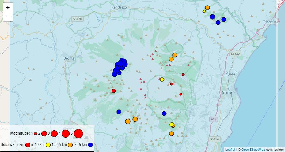 Today, on the INGV earthquake map, we can see an earthquake swarm that already occurred on August 30th. The earthquake sequence consisted of 13 tremors with magnitudes greater than 1. The strongest earthquake occurred at 16:28 UTC and reached a magnitude of Md 2.9. The hypocenter was located at a depth of 21 km, and the epicenter was identified as 1.4 km southwest of Monte Scavo, a wooded scoria cone in the northwest of Mount Etna. The nearest major town is Bronte. The weakest earthquake had a magnitude of 1.4 and had a similarly deep hypocenter as the strong earthquake. It is suspected that the earthquake swarm was triggered by magma rising in the upper part of the asthenosphere, on its way to penetrate the Earth’s crust. Earthquakes at this depth are more the exception than the rule, but it cannot be ruled out that they could have been purely tectonic in origin.
Ebeko erupts ash clouds up to 4000 meters in height
 The volcano Ebeko on Paramushir has been active in the past two days, emitting ash clouds up to 4000 meters above sea level. These ash clouds have been drifting southeastward due to the wind. The KVERT observatory has confirmed the volcanic activity and reported weak thermal anomalies detected at the crater. It was noted that eruptions could occur at any time, causing ash clouds to rise to 3500 meters in height, posing a danger to low-flying aircraft. The aviation alert status is currently set to “orange.”
Earthquake Magnitude 7.0 near Bali
Date: 28.08.23 | Time: 19:55:32 UTC | Location: -6.810, 116.563 | Depth: 516 km | Magnitude: 7.0
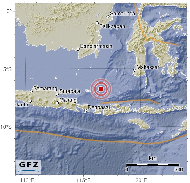 The Indonesian Bali Sea was shaken by a strong earthquake with a magnitude of 7.0 yesterday evening. Initially, the magnitude was reported as 7.1, but it was later slightly downgraded. The seismic event occurred at 19:55:32 UTC (03:55:32 local time) and had an epicenter located 188 km north-northwest of Labuan on Lombok Island. The vacation island of Bali is approximately 220 km away from the epicenter. Closer was the coast of the small island of Soemoerboengkar, which is only about 30 km from the epicenter. Nevertheless, the strong tremor had no catastrophic consequences, and no significant damage was reported. A tsunami was also not generated. However, the island residents clearly felt the strong tremor.
Popocatépetl: Ash Cloud and Tremor
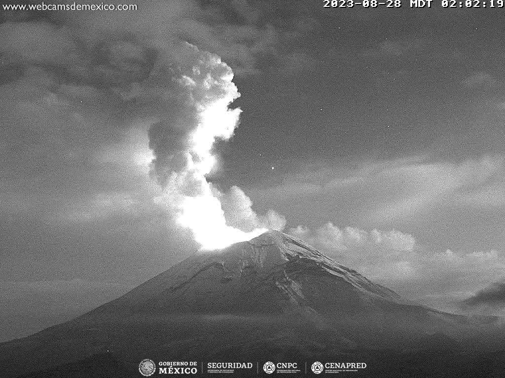 At the Mexican volcano Popocatépetl, the tremor remains elevated. Yesterday, CENAPRED reported a tremor lasting a total of 349 minutes. However, only 9 instances of ash and steam exhalations were observed. In exchange, today an ash cloud was reported, which according to VAAC reached a height of 7600 meters and was carried in a northwesterly direction. On nocturnal live webcam images, an illuminated steam cloud is visible, indicating the presence of glowing lava within the vent or even the growth of a lava dome.