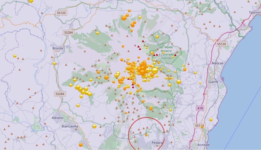
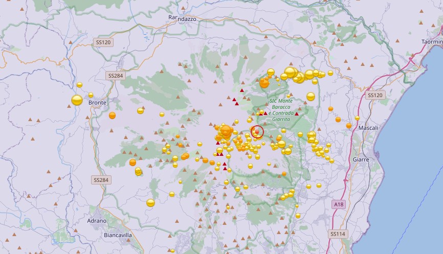
 Already yesterday I reported about an earthquake swarm, which today presents itself much stronger than it first appeared. SismoWeb (INGV) today shows 53 earthquakes for November 5. Most of the tremors occurred about 2 km south of Pizzo Deneri on the northern side of Etna. The strongest single quake occurred on M 3.1 with a hypocenter at 3.2 km depth. The majority of the other quakes had magnitudes between 1 and 2. The hypocenters were mostly at depths less than 5 km. This was the strongest earthquake swarm of the last months at Etna. It is very well possible that the quakes were caused by rising magma. An eruption in the upper part of the Valle del Bove, respectively at the base of the Northeast Crater is possible in the medium term. However, it is known that the entire eastern flank of the volcano is moving and the quakes could also be related to tectonic processes.
 Marc Szeglat
Vulkaneifel: Soil uplift at Laacher See proven
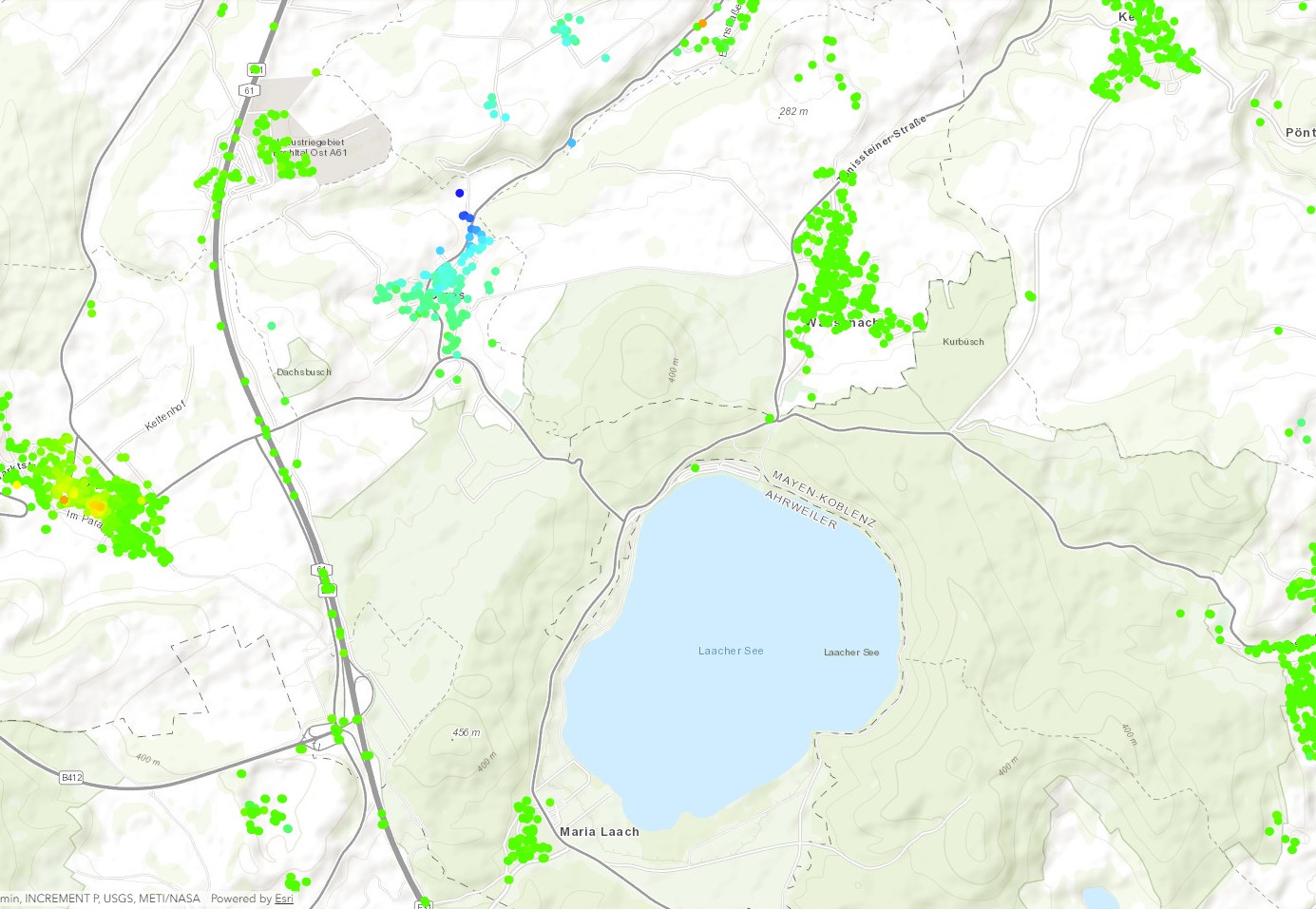 It has often been speculated whether a series of earthquakes at the Laacher Lake volcano, which occurred between 2013 and 2018, might not have been related to the intrusion of magmatic fluids. Now this assumption seems to be confirmed. The confirmation can be found in the form of a new map of the German authority BGR (Bundesanstalt für Geowissenschaften und Rohstoffe), which has been prepared within the framework of the Boden-Bewegungsdienst-Deutschland.
With the help of this map, primarily ground movements which have been caused by mining are to be represented. These are usually ground subsidence which can cause damage to the infrastructure. In fact, the satellites used to create the map did not only detect ground subsidence, but also ground uplift. It is located under the village of Glees, 2 km northwest of Lake Laach. The satellite data show that the ground rose by about 40 mm between 2014 and 2019.
In my opinion, the newly discovered ground uplift would justify a continuous observation of the Laacher See volcano and its surroundings, at least until it can be excluded that the ground deformation is of magmatic origin. Although it is still a small-scale uplift, without regular observation it is not known whether it is increasing. Theoretically an eruption could occur within a few months/years. If the fluid is magma.
Sinabung increases its activity
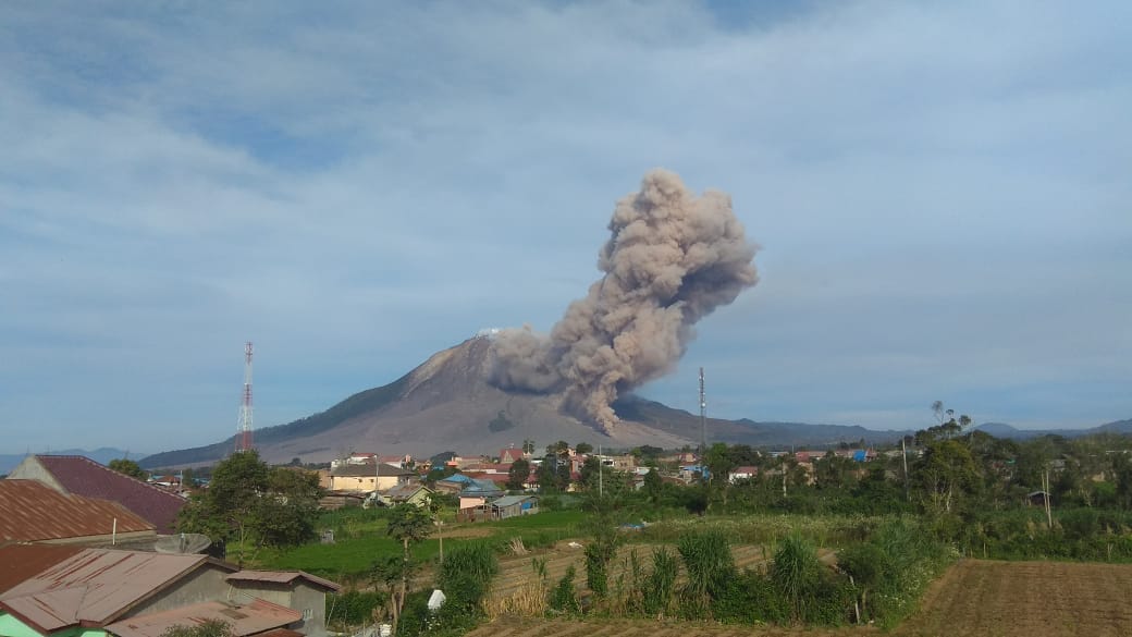 The volcano Sinabung is located on the Indonesian island of Sumatra and increased its activity. Already on October 20, the seismic activity increased rapidly, and in addition to volcanically induced earthquakes, numerous seismic signals were picked up, which were triggered by the discharge of debris avalanches. Yesterday at least one pyroclastic flow was generated, which was photographed but has not yet been included in the MAGMA/VSI updates. The stream had a length of about 1500 m and was active for almost 4 minutes. The events suggest that the lava dome has received a new growth spurt and reached a critical size. It is expected that further pyroclastic flows will be generated in the near future. There is also the danger that a larger part of the dome will collapse. Visual observations of the dome are rare these days because the top of the volcano is mostly hanging in the clouds.
Iceland: Earthquake M 5.6
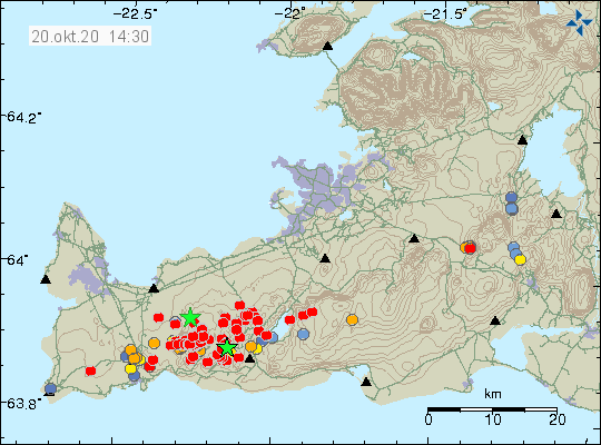 On the Icelandic Reykjanes Peninsula, the earthquake struck this afternoon at 13.43 UCT with a magnitude of 5.6, with the epicenter located 3.9 km west of Krýsuvík and only a few kilometers from Grindavik. The hypocenter was located at a depth of 3.3 km. The quake could be felt in large parts of southwest Iceland and shook the capital. For Iceland it was a strong quake. There were numerous aftershocks, although I would honestly say that the main quake triggered a seismic swarm. So far 219 quakes have been registered, 12 with magnitudes greater than 3.
Alaska: Earthquake Mw 7,5
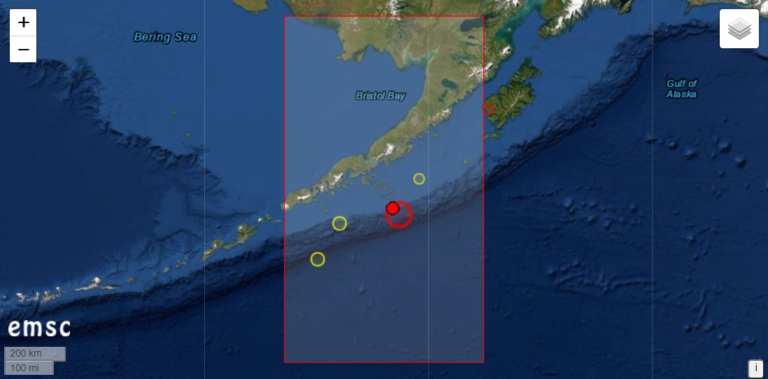 Off the coast of the US state of Alaska, the earth shook last night with a magnitude of 7.5, the epicenter being located 84 km southeast of Sand Point. This is a place on the Aleutian island of Unalaska. The hypocenter was at a depth of 40 km. Despite the relatively large depth of the earthquake epicenter there was a tsunami alarm. The same applies to larger damages. The region is only sparsely populated. In relative proximity to the location of the earthquake are some volcanoes that are classified as potentially active: Mount Makushin, Mount Okmok and the volcanic island of Bogoslof, to name only 3. The volcanism of the region is directly related to the Aleutian subduction zone where the earthquake occurred.
As is typical for earthquakes of this magnitude, there were numerous aftershocks. The strongest one had the magnitude 5.9 and further aftershocks must be expected.
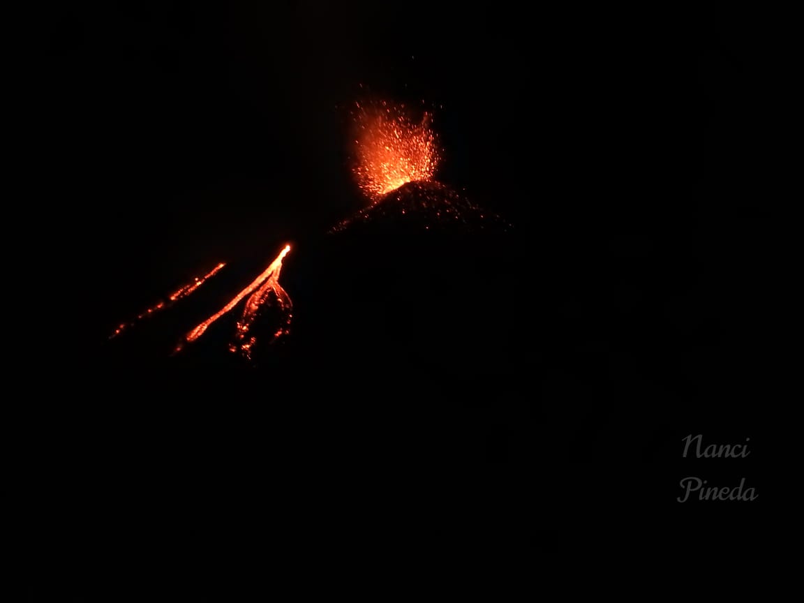
Etna: Video from the NE crater
Etna in Sicily is still active from 2 craters. Satellite images reveal 2 thermal anomalies: one originates from the New Southeast Crater, which is known to be strombolian active and has ejected ashes in phases a few days ago. The 2nd anomaly manifests itself in the Northeast Crater. The summiter Elia Finocchiaro climbed it yesterday and brought a nice video of the activity in the crater. Such images of Northeast Crater are rare. You can see 3 active vents from which lava sprays out. From one of the small vents a strombolian eruption was generated. Around the vents cones are already forming.
The tremor did not fluctuate as strongly in the past 2 days. But there were more earthquakes under the central crater area, in Valle del Bove and at the Pernicana fault zone. MIROVA registered a high thermal radiation with an output of 170 MW. Should such a value be measured repeatedly, there could be an intracrater lava flow.
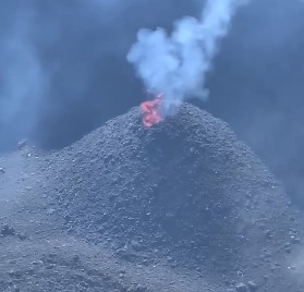
Pacaya: Activity increased
 Yesterday the activity of Pacaya in Guatemala increased again. INSIVUMEH reports 3 active lava flows, which were extracted from different vents at the base of the McKenney crater. The longest flow reached a length of 400 m and flowed towards the northeast. The second flow was 300 m long and moved on the north flank, while a third lava flow on the west flank had a length of 200 m. Lava flows there did not occur during the last months. Furthermore, the McKenney crater was strombolian active. During the last night the activity seems to have decreased again a little bit: the only moderate heat radiation displayed by MIROVA indicates this.
La Palma: Seismic swarm
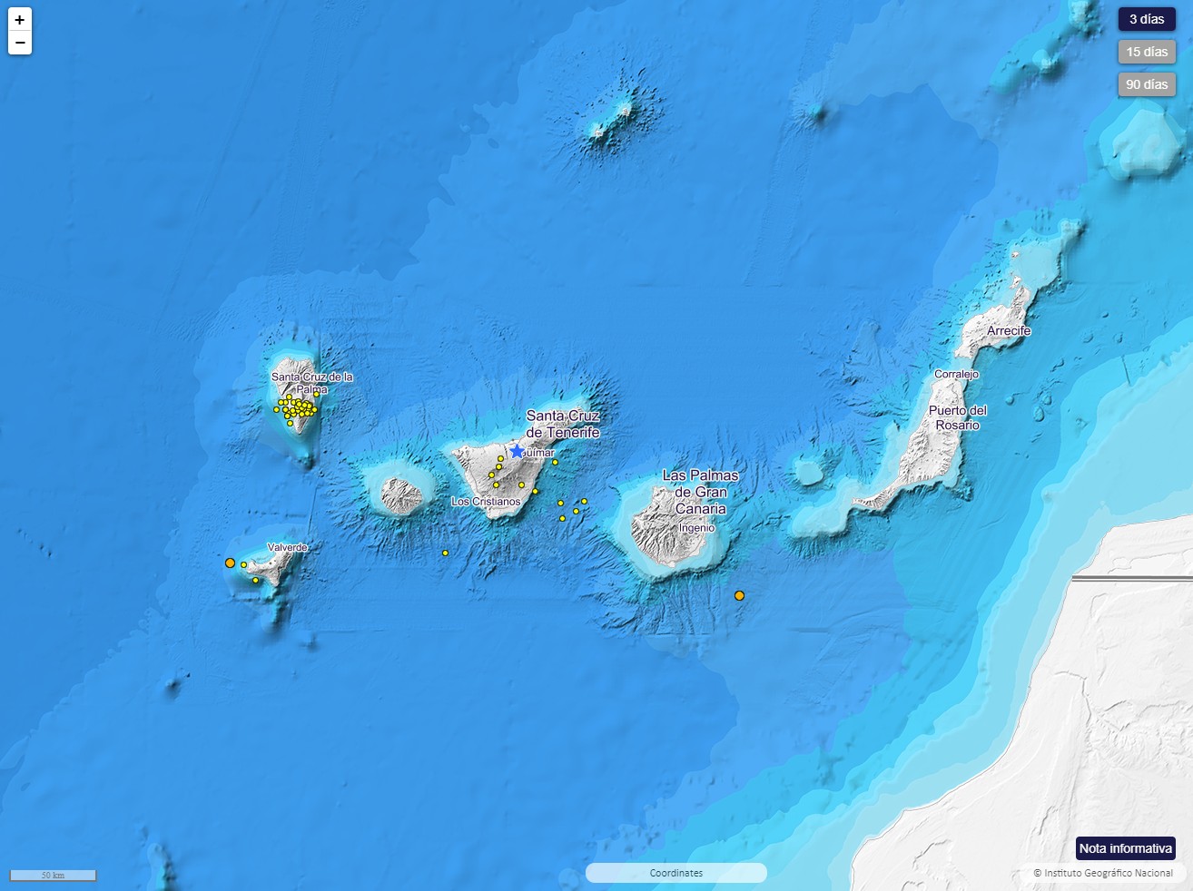 The Canary Island La Palma was again hit by a swarm quake yesterday morning. The seismographs recorded 25 tremors with magnitudes between 1.6 and 2.0. The hypocenters were at depths between 20 and 45 km. In this area of the asthenosphere, it is usually ascending magma that triggers light tremors. The epicenters were located in the south of the island, which was formed by eruptions.
In addition, seismicity is also increased in other regions of the Canary Islands. For example, it shook unusually often in the area of Tenerife and El Hierro is also still affected by sporadic quakes. Although there are no indications of an imminent volcanic eruption, in the longer term an eruption could occur again. In my opinion the most promising candidate is La Palma.
Etna with further earthquakes
 The day before yesterday there were several interesting earthquakes on Etna. The strongest one had a magnitude of 2.9 and manifested 1100 m east of the central crater. The hypocenter was located at a depth of only 700 m. In the same region there were 4 other quakes. In the north of the volcano, a quake M 2.7 occurred, which manifested itself at the Pernicana fault. This quake was also very flat. The INGV located the source of the earthquake at only 600 m depth. There was another quake M 1.2. The quakes at the fault zone are of tectonic origin, but could still be indicators for magma rise, because the magma can press on the fault zones and thus is able to trigger earthquakes.
Of course Etna is not only seismically active, but also eruptive. In the last days eruptions from the saddle vent of the New South East Crater continued. Strombolians and phases with ash ejection occurred. The tremor fluctuates at the border of the red zone. There are no indicators for short-term changes in the eruption process. In the medium term a more intensive eruption phase could brew again.
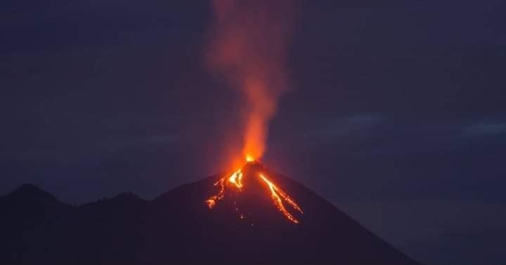
Pacaya: Update 09.10.20
 The Guatemalan volcano Pacaya is leading the headlines today because it erupts at least 2 lava flows. They originate from the base of the intracrater cone in the McKenney crater and generate a thermal signal with 333 MW power. The flows flow on the southeast and northeast flanks and split into several arms. Debris avalanches descend from the front of the flows. Exact longitude data are still missing. INSIVUMEH reported yesterday that there is only one stream on the south flank. It had a length of 250 m. The longer of the two rivers will be of this size today. Furthermore, the Pacaya is strombolian active and lets glowing tephra rise up to 100 m high. The eruption can be seen from Guatemala City. Numerous pictures were shared on Twitter.