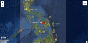
 The Philippines were hit by a severe earthquake with a magnitude of 6.8. The hypocenter was located at a depth of 15 km. These data are from EMSC, PHILVOLCS gives the magnitude as 6.6 and the depth as 21 km. The epicenter was located in the Samar Sea. The strait is enclosed by the islands Samar, Leyte and Masbate. The nearest town was San Pedro, 20 km away.
Although it was already a relatively strong earthquake, the damage seems to be limited. This is probably due to the rather great depth of the earthquake’s focus. According to media reports, a family was trapped in their collapsed house. Cracks were discovered on several bridges and in streets. However, the great catastrophe did not occur.
There were (and still are) numerous moderate aftershocks. Most of them have magnitudes in the range of 3.
Strong earthquakes can influence volcanoes in their eruptive behaviour. In fact, there are reports in social media according to which the Taal volcano, a good 400 km away, reacted to the quake with increased steam emissions. Images are circulating with a steam cloud several hundred meters high above the volcano crater. The volcanologists of PHILVOLCS report only a 20 m high steam cloud, as it has been standing over the volcano almost constantly since the end of the eruption in January this year. The cloud in the pictures is called a meteorological cloud. For this, the nearby Mayon volcano probably actually emits a steam plume. Instead of ascending 200-500 m as usual, it reached a height of 750 m today. A volcano-tectonic earthquake was recorded. At Taal Volcano, the number of quakes rose from 2 to 5.
In general, it is probably too early to estimate whether the earthquake will have a lasting effect on the behaviour of the volcanoes. I do not see any signs of an imminent eruption.